

Decoding flash floods with GeoAI in Vietnam’s Northern Highlands - Part 1: From policy frameworks to data frontiers
14/11/2025TN&MTFlash floods in Vietnam’s northern mountains are not only tallied in annual disaster statistics, they shape the land, livelihoods, and planning decisions across entire districts. As climate change intensifies extreme rainfall, the demand for reliable and accessible hazard maps becomes urgent. A research team from the Institute of Mechanics, Vietnam Academy of Science and Technology (VAST) has demonstrated that Geospatial Artificial Intelligence (GeoAI) can meet this demand, producing high-precision, data-driven maps of flash flood risk for the northern communes of Tuyen Quang province, an area once part of Ha Giang’s rugged highlands.
Why a new approach was needed
Vietnam ranks among the ten countries most severely affected by climate change. Over the past two decades, natural disasters have caused economic losses equivalent to 1.0–1.5% of GDP each year. Recognizing this, the Law on Natural Disaster Prevention and Control (2013) and the National Strategy on disaster risk reduction to 2030, with vision to 2050, set ambitious goals: to reduce human losses from flash floods and landslides by 50% and to curb associated economic damage.
Under this policy framework, specialized agencies have been working to develop large-scale hazard maps for flash floods and landslides at mapping ratios of 1:10,000 and 1:2,000. Yet, in Vietnam’s mountainous regions, the terrain is deeply dissected, data availability remains limited, and environmental variables fluctuate significantly across space and time, making traditional hydrological or statistical models difficult to apply comprehensively.
Against this backdrop, GeoAI — the fusion of machine learning and Geographic Information Systems (GIS) — has emerged as a fitting solution. It allows models to “learn” from multiple layers of both natural and human-induced factors, capturing the nonlinear and multidimensional relationships among topography, soil, land cover, hydrology, and extreme rainfall — the very conditions that trigger flash floods.
Notably, the draft technical circular of the Ministry of Agriculture and Environment also recommends the application of GeoAI in hazard zonation. The study led by Le Như Nga represents one of the first provincial-scale efforts in Vietnam to apply GeoAI to flash flood risk mapping, focusing on the northern communes of Tuyen Quang province, which were historically part of Ha Giang’s mountainous area.
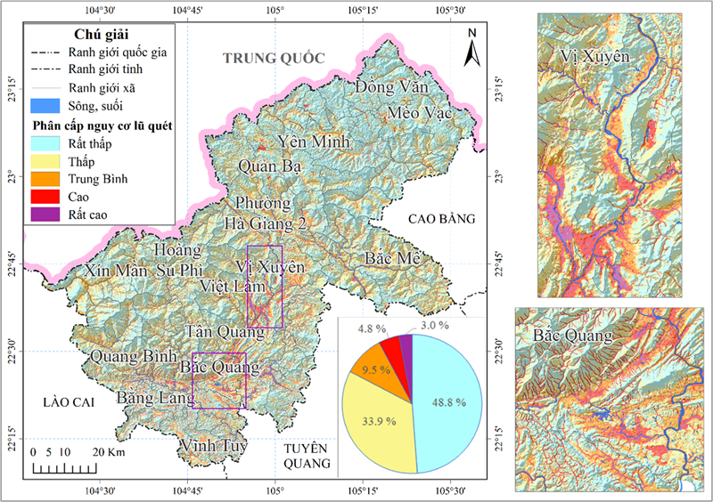
Study area: A complex mountainous terrain of overlapping risks
The study area covers the northern communes and wards of Tuyen Quang province, formerly under Ha Giang province, with a total area of 7,927.55 square kilometers. The terrain is mountainous and sharply dissected, with elevations ranging from 40 meters to over 2,400 meters, and an average range between 800 and 1,200 meters.
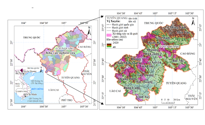
Geographical location of Tuyen Quang province within Vietnam (left) and the study area showing terrain and communes/wards that have experienced flash floods (right)
Land use is a mixture of agriculture (21.6%), forest (51.7%), and non-agricultural land (5.0%), reflecting a typical mosaic of agroforestry livelihoods and small settlements along stream valleys. These settlement patterns, combined with increasingly extreme rainfall, result in frequent flash floods and debris flows, 61 recorded events between 1989 and 2018, averaging about two events per year.
Building a robust multi-source dataset
Unlike many previous small-scale or single-source studies, this research constructed a comprehensive, synchronized multi-source dataset that integrates topographic, geological, soil, hydrological, and remote-sensing data:
Topography: 24 digital topographic maps (scale 1:50,000, MONRE, 2019) in vector DGN format were converted from elevation points and contour lines into a 20-meter Digital Elevation Model (DEM) using the Triangulated Irregular Network (TIN) method. This DEM formed the basis for calculating elevation, slope, aspect, curvature, basin morphology, and commune/ward boundaries.
Soil: 1:100,000 soil maps (MARD, 2004) in TAB format were used to derive the soil index layer.
Geology: Five geological maps (1:200,000, MONRE 2000) were digitized to build the geological structure layer.
Land use: 1:100,000 land-use maps (MONRE 2019, DGN format) were processed into a land-use index layer.
Rainfall: Hourly rainfall data from 34 automatic stations (2020–2023, MONRE) were interpolated using Kriging to generate maximum rainfall layers for 24-hour, 72-hour, and 120-hour intervals.
Remote sensing: Three cloud-free Landsat-8 scenes (P127R44, P127R45, P128R44; from 2021 and 2023; cloud cover <5%) were used to calculate the Normalized Difference Vegetation Index (NDVI) from Bands 5 and 4.
Flash flood inventory: 37 historical flash flood events (2001–2022) were compiled from local reports, detailing occurrence time, location, magnitude, and type, to support ground-truthing.
Field survey: Conducted in May 2024 across the entire former Ha Giang area, documenting debris traces, slope characteristics, soil profiles, and vegetation cover related to past flood activity.
All data were integrated into a unified ESRI Geodatabase (VN2000–Ha Giang projection), with Landsat imagery stored in raster format and all other datasets as vector layers. The final modeling used 14 index layers, grouped by: Topography and geomorphology (elevation, slope, aspect, curvature); Geology and soil; Land use and vegetation (NDVI); Hydrology (catchment area, drainage density, Topographic Wetness Index); and extreme rainfall (24h/72h/120h maximum precipitation).
Soil and land-use layers were assigned hydrological weights following NRCS (USDA) guidelines before rasterization. All indicators were averaged by catchment unit to reflect water accumulation and flow processes in upper basins, an innovation that aligns more closely with the physical mechanisms of flash floods.
Grounded in data: Over 11,000 labeled points for model training
The team developed a binary training dataset (“very high likelihood of flash flood occurrence” / “no likelihood”) comprising more than 11,000 labeled points derived from flood inventories, field observations, and high-resolution Google Maps imagery. Positive samples were placed along riverbeds and floodplains, areas of concentrated surface runoff, while negative samples were located on mountain ridges and slopes. The dataset was standardized and randomly split into 60% for training and 40% for validation.
Given the large dataset and the number of variables, model computation was implemented on Google Colab integrated with Google Drive. OSGeo-GDAL was used for reading and writing GeoTIFF files; modeling was performed in Python using GridSearchCV for hyperparameter optimization, Permutation Importance and SHAP for variable contribution analysis. Spatial operations were executed in ArcMap, ArcGIS Spatial Analyst, and ArcHydro, while commune-level statistics were generated with Zonal Statistics (Tabulate Area) tools.
The next installment will present the spatial results of the GeoAI model — the five-tier hazard map, commune-level risk distribution, and the implications for land-use planning, early warning, and disaster prevention policies in northern Tuyen Quang.
Viet Anh
Source: All data, methods, results, locations, and conclusions in this article are drawn directly from the research report: Le Nhu Nga, Le Thi Hong Van, and Trinh Thi Thu Thuy, “Development of flash-flood hazard maps for the Northern communes of Tuyen Quang province (Former Ha Giang province) using Geospatial Artificial Intelligence,” Institute of Mechanics, Vietnam Academy of Science and Technology (VAST).
Post Related

Building the institutional framework for electronic land use certificates in Vietnam’s digital transformation era
Part 2: Alternate wetting and drying (AWD) - A key pathway to low-emission rice production in Vietnam
Part 1: Water use efficiency - The foundation of Vietnam’s green agricultural transition
Gravity-driven water filtration system: A new hope for flood-affected communities

Vietnam - South Korea strengthen cooperation on digital transformation in the water sector

Vietnam to host AWC 2025: Toward sustainable water governance and digital transformation
Vietnam and Australia cooperate to advance the circular economy and sustainable agriculture

Vietnam and Queensland advance agricultural cooperation toward sustainability and trade balance